Once upon a time, 13 thousand years ago, the two islands were connected by a strip of land, or rather by a kind of archipelago, now submerged. Here’s what the expedition discovered in the Sicilian Channel.
There was a time, not too distant on a geological scale, when you didn’t need a boat to reach Malta from Sicily. All it took was walking. Then the sea erased everything — and what is re-emerging today, thanks to an Italian-Maltese scientific expedition, is not at all what researchers expected to find.
A bridge that wasn’t a bridge
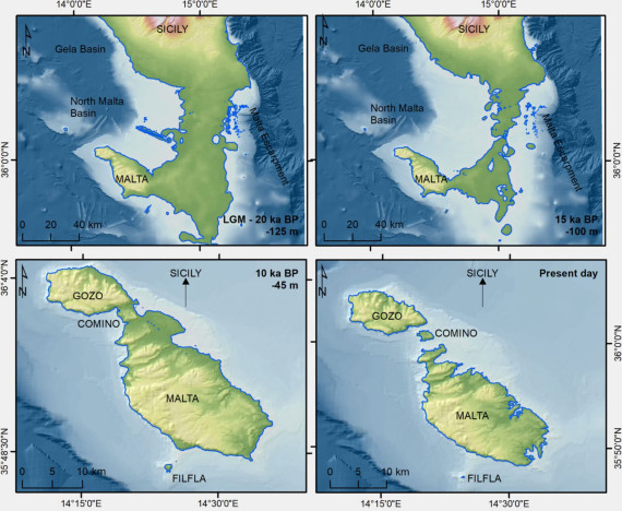
Imagine standing on the south-eastern coast of Sicily, tens of thousands of years ago, looking towards what we now call Malta. Instead of the over 90 kilometers of open sea that today separate the two islands, an emerged land would have stretched out in front of you, the result of a phenomenon that has redesigned the coasts of the entire planet. During the last ice age, in fact, enormous ice caps trapped colossal quantities of water, causing sea levels to drop.
The most recent research places the point of maximum lowering around 22,000 years ago, when the Mediterranean was about 120 meters lower than today – not 130, as we sometimes read: a detail that the BRIDGES project researchers themselves wanted to clarify and this strip of land could emerge, facilitating the movement of animals. With the Mediterranean receding, a long strip of land emerged between Sicily and Malta, remaining essentially intact for millennia. But here comes the first twist: that connection, apparently, was not the simple “land language” that manuals and popular reconstructions have always imagined.

The maps that rewrote lost geography
To tell how we know it, we need to talk about the BRIDGES expedition, which set sail on board the oceanographic vessel Blue Gaia of the CNR between the end of December 2025 and the first days of January 2026: it was in that winter period that the ship sailed the Sicilian Channel to explore the seabed. The Institute of Marine Sciences of the CNR (Cnr-Ismar), the National Institute of Oceanography and Experimental Geophysics (OGS) and the University of Malta collaborated on the project, under the guidance of researchers Maria Filomena Loreto and Emanuele Lodolo. This is a paradox if we consider that it is one of the most navigated stretches of sea in human history, yet as Lodolo himself observed, «This area, in particular, is completely unknown from the point of view of detailed underwater mapping».
The old surveys, dating back to the mid-twentieth century, had too low a resolution to tell anything more than a shadow.
The new high-resolution maps have instead revealed a very complex seabed: elongated and discontinuous ridges that run for tens of kilometers, depressions, sheltered basins that recall modern coastal lagoons protected by natural barriers.
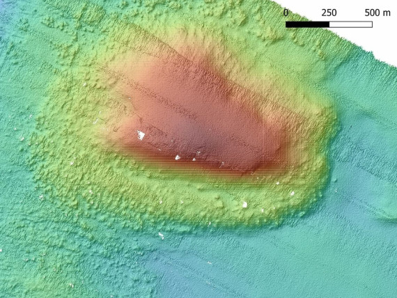
Not a single and continuous corridor, in short, but something more similar to a submerged archipelago – a mosaic of islands, narrow channels and shallow waters which, as the sea rose, progressively fragmented and then swallowed up. One detail in particular sparked the team’s curiosity: along the western edge of the ancient connection, the instruments identified an irregular formation that could be an ancient coral reef.

Unique ecosystem
If confirmed, it will serve to better understand what type of coastal ecosystem developed in that now disappeared landscape. The team also used acoustic instruments to “see” beneath the seabed and brought sediment samples containing ancient deposits back to the surface. Laboratory analyzes and radiocarbon dating will be conducted on these fragments, to understand exactly when each portion of that world disappeared under water.
Who walked on it?
Here the most intriguing question arises, the one to which no one yet has a definitive answer: has anyone really gone through it? It is plausible that animals used that corridor to move between the two land masses and that groups of Sicilian hunter-gatherers explored the coastal areas in search of resources. But if humans ever set foot on that now submerged land and crossed it to Malta, it remains an archaeological black hole. What we know for sure is that, by the time humans actually arrived in Malta, the land bridge had already long disappeared.
For years it was believed that the island’s first inhabitants were Neolithic farmers who landed around 7,500 years ago. A study published in Nature in April 2025 it moved the clock back: excavations at the site of Latnija, in the north of Malta, revealed traces of hunter-gatherers who lived already 8,500-8,900 years ago, who left behind stone tools, hearths and remains of meals based on fish, molluscs and birds. What makes the discovery even more fascinating is that those hunter-gatherers found no bridge waiting for them: the land connection had been submerged for at least 4,500 years, so they must have faced a sea crossing of about 100 kilometers — a remarkable feat for the time, demonstrating how the Mesolithic communities of the Mediterranean already knew how to navigate open water well before the arrival of agriculture.
It is no coincidence that archaeologist Eleanor Scerri, of the Max Planck Institute of Geoanthropology, who led the study on Latnija, observed how incomplete knowledge still is about the first inhabitants of the island, wondering whether they were really the first ever. The temporal contrast is also interesting: Sicily was already inhabited around 16,000 years ago, while Malta only became a stable human presence around 6,000 years ago – a delay of millennia that the sea, perhaps, only partially explains. A suggestive possibility therefore remains open: that the human history of Malta has its roots in an even more remote era than that documented today, perhaps precisely in the times in which the land bridge – or the archipelago that replaced it – was still passable.
A pantry lost in the Mediterranean
There is one last hypothesis, perhaps the most suggestive of all: that that territory was not just a passage, but also a source of sustenance. Sheltered lagoons and shallow waters are, even today, environments rich in fish and molluscs. If similar ecosystems dotted the vanished corridor, they may have attracted human groups seeking food along the coast without them feeling the need—or having the means—to travel all the way to Malta.
For now, no artifacts and no human settlements have been identified on that ancient submerged landscape. The link between the lost bridge and the first migrations remains a fascinating hypothesis, not an established fact. But the new maps have returned something that the Mediterranean, today, no longer offers: proof that once upon a time you could walk, without getting your feet wet, from a continent to an island that seems made to remain isolated.