An Italian company that wants to offset its emissions can now buy the CO₂ stored by a specific forest, in a specific municipality, with a specific average age of the trees. The national register of voluntary carbon credits, established by law in 2023 and made operational by the guidelines signed in October 2025, is entrusted to CREA and should become fully operational this year, relying on the national forest information system. It is the first public instrument in Italy that transforms the carbon of a forest into a salable asset.
The question on which everything else depends remains: how do we know that that carbon is really there, and that it will remain there?
It’s not an academic question. The international voluntary market has gone through a crisis of credibility which has caused prices to collapse, and at the center are the REDD+ projects: the acronym, created within the UN in 2007, indicates the programs that pay someone not to cut down a forest. The idea is simple, the carbon that remains inside the trees is worth money, and that money must make the standing tree cheaper than the cut down tree. The “plus” added at the end covers activities that increase carbon, from conservation to forest management, not just those that avoid losing it.
In 2023, a study published in Science analyzed 26 forest conservation projects in six countries and concluded that most had not significantly reduced deforestation, and that the few that had succeeded had achieved much less than they claimed.
In October 2025, a second work, again in Science, expanded the sample to 52 projects in twelve tropical countries: less than a fifth achieved the emissions reduction objectives they had set themselves, and only 13.2 percent of the credits put on the market were supported by the data. The budget is less catastrophic than that of 2023, but the verdict does not change: much more clean air has been sold than has actually been produced.
The crux, in both cases, is measurement. A carbon credit is a number, and that number comes from an estimate.
Count trees without counting them. Measuring how much carbon a forest contains is a very complex task. The classic method is called sample inventory: test areas are delimited, the circumference of the trunks is measured at one meter and a half from the ground, the height is estimated, and then the allometric equations are applied, formulas that starting from those two numbers return the volume of wood, then the biomass, then the carbon.
Half of a tree’s dry weight is carbon.
It works, but it is slow and expensive, and above all it photographs an instant. A forest, however, changes: it grows, ages, is cut down, burns. A loan that is to remain valid for twenty years needs to be monitored for twenty years.
Hence the rush for instruments that look at the forest from above. The European Space Agency launched the Biomass satellite on 29 April 2025 from Kourou with a Vega-C rocket: it features the first P-band synthetic aperture radar ever taken into space. The long waves of the radar pass through the foliage and return the echo of the trunks and large branches, which is where almost all the carbon in a tree is. Until yesterday, satellites saw the green roof of the forest, Biomass sees its skeleton.
The forest that lives inside a computer. The next step is the digital twin. The idea was born in the aerospace industry, where a ground model was needed that could reflect the state of an aircraft in flight in real time, and became established in the early 2000s. It is not a map and it is not a simulation: it is a virtual copy of a real object, continuously updated by data arriving from the original. If the object changes, the twin changes.
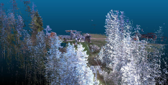
Applied to a forest, it means a three-dimensional reconstruction in which each tree has a position, a height, a diameter and a species, and in which these values are updated as new findings arrive. At that point the forest becomes questionable: how much biomass is there on this side, how much will it grow in the next ten years, what happens to the carbon stock if a year of drought slows down growth.
In Italy, RUMA is working on this, a benefit company, i.e. with common benefit objectives included in the statute, founded in 2022 in Rovereto in the spaces of Progetto Manifattura as a result of the European SATURN project, coordinated by the Edmund Mach Foundation with the University of Trento. The starting point was a question about environmental accounting. «The research aimed to analyze the impact of human activities, in terms of emissions, and to compare it with the territory’s ability to regenerate the resources consumed», says Angelica Pianegonda, CEO of the startup. «Despite the fact that Trentino is mainly covered by natural areas and forests amount to around 63 percent of the total, research has revealed that people consume many more resources than nature is able to regenerate».
From there the EcoSense platform was born, which combines satellite images, drone footage and field inspections to estimate the biomass of each individual green area, and which, with the certification of an external partner, can declare how many credits each stretch of forest corresponds to. The amount of carbon dioxide that plants store depends on the type and age of the trees and the risk of fires and the calculations cannot stop at today’s photograph: «Our digital tools and timely field checks allow us to carry out calculations that do not only concern the current state of the trees, but also their development», explains Pianegonda, given that a carbon credit project must last at least twenty years.
However, the digital twin also has a second job, much more prosaic: knowing where the vegetation is growing helps to understand when it will interfere with a high voltage pylon, a railway line or a road. The same three-dimensional map that applies to carbon applies to infrastructure maintenance, and this is probably the market that pays the bills today.

Nine million poorly cared for hectares. The Italian forestry heritage is larger than we think, and we know it less well than it seems. The official data on the surface area is still that of the National Inventory of forests and forest carbon sinks: 11 million hectares, 36.7 percent of the territory, of which just over 9 are classified as actual forest. The problem is that that inventory refers to 2015 and is based on a soil reading made in 2013. The Forestry Map of Italy, the first national map of forests since 1936, presented by CREA at the end of 2024, indicates over 10 million hectares of forest according to the definition of the Consolidated Forestry Act, around a third of the country, of which 6.5 million are above 500 metres.
How much those numbers matter was seen last year. In May 2025 ISPRA announced that in 2023 the land use and forestry sector absorbed 53.6 million tonnes of CO₂ equivalent, almost 14 percent of national emissions, the highest share ever recorded. Not because the woods had suddenly grown: because the calculation was redone with the new Forestry Map, with an updated database on timber harvests and with the first findings of the new inventory. Same trees, better tools, different result.
Several insiders were surprised.
Precisely for this reason, the IFNI, the fourth Italian forest inventory, began in 2025, abandoning the ten-year frequency: a fifth of the sampling points are recorded each year, with statistics updated annually. A decade, they concluded at CREA, is too long for a forest that changes at the speed with which the climate changes.
Then there is the question of treatment. The 2015 inventory found that only 15.3 percent of forested area had a detailed management plan, and that share was declining. A dense and untended forest absorbs less than a managed forest, is more exposed to fires and parasites, and is worth little to the owner, because the wood alone does not repay the costs. This is exactly the register’s bet, to give an economic value to care and not to ownership. «The system will allow us to recover those woods that have been abandoned because not even the sale of timber is profitable enough for the owners of the land to invest in care and maintenance», says Pianegonda.
Measuring better is not enough. Here, however, it is important to be precise about what satellites and digital twins resolve. They solve the quantification: how much carbon is there, where, and how it varies. They don’t resolve additionality, that is, the most uncomfortable question of all: would that carbon have been absorbed anyway, even without the project and without the money from the company that bought the credits? This is exactly where the tropical projects analyzed by Science failed – not on the tree count but on the hypothetical scenario against which the count was compared.