The El Niño climate phenomenon could reach extraordinary intensity in the coming months and prolong its effects for part of 2027. The World Meteorological Organization (WMO) has warned that this episode could be among the most intense on record, with temperatures in the equatorial Pacific Ocean well above usual values.
Mar Gómez, meteorologist TheTime and doctor in Physical Sciences, highlights that “we are facing a truly exceptional climate situation.” However, although this phenomenon can alter the weather patterns of numerous regions of the planet, it is not yet possible to determine what consequences it will have in Spain during the next winter.
The evolution of El Niño will be key to understanding the scope of this episode, which could also contribute to raising the average global temperature in 2027. Its development adds to a context of warming caused by climate change, so the coming months will be important to evaluate its impact.
El Niño could reach extraordinary intensity
The latest forecasts from the World Meteorological Organization suggest that El Niño could become one of the most intense episodes on record and even surpass historical records. As explained by Mar Gómez in the middle TheTime and in videos on their social networks, “the El Niño phenomenon is experiencing an extraordinary intensification.”
One of the most striking indicators is the temperature of the equatorial Pacific Ocean. The data collected contemplates anomalies of up to 3.8 degrees above normal for the quarter between November and January. This is a very high difference that reflects the magnitude of the ocean warming associated with this episode.
However, the meteorologist warns that it is still necessary to follow its evolution before confirming whether it will finally be the most intense episode on record. To do this, it will be necessary to observe both its development and the average intensity it reaches over several months.
The WMO also points out that the phenomenon could last until 2027. This means that its effects would not have to be limited to the last months of 2026, although its duration and scope will depend on how the episode evolves.
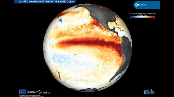
What consequences can El Niño have on the global climate?
El Niño is not only about an increase in sea water temperature. As Mar Gómez explains, it is an alteration of the coupled system between the ocean and the atmosphere that modifies the tropical atmospheric circulation, weakens the trade winds and displaces the main convection regions.
These changes can propagate over long distances through so-called atmospheric teleconnections. As a result, temperature and precipitation patterns can be modified in different regions of the planet, with consequences that vary depending on the area and the characteristics of each episode.
Among the possible effects associated with El Niño are periods of drought in some regions and episodes of intense rain and flooding in others. Therefore, it does not cause the same weather conditions throughout the world, but rather alters the usual distribution of precipitation and temperatures.
In addition, the phenomenon can favor the transfer of heat from the Pacific Ocean to the atmosphere, which contributes to raising the average global temperature. This effect may appear with a certain delay compared to the moment of maximum intensity of El Niño.
For this reason, 2027 could see an additional boost in global temperatures. However, this does not necessarily mean that it will become the warmest year on record, since other factors also intervene that influence the planet’s temperature.
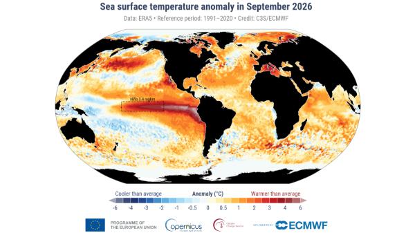
How will El Niño affect winter in Spain?
Despite the forecasts regarding the intensity of the phenomenon, at the moment it cannot be said that Spain will have a warmer, rainier or drier winter as a direct consequence of El Niño.
Mar Gómez explains that, unlike what happens in other regions of the planet, where the relationship between this phenomenon and precipitation or temperatures is better established, in Spain there is no clear and direct correlation with this phenomenon that allows us to anticipate a specific meteorological pattern.
Therefore, the possible intensification of El Niño should not be interpreted as a sign that the Spanish winter will necessarily be warmer or rainier. To know how the weather will evolve in our country, it will be necessary to pay attention to the specific weather forecasts and the evolution of the atmosphere during the coming weeks and months.
The meteorologist insists that, although the current indicators are extraordinary, we still have to wait to determine if the episode finally reaches record intensity. The scientific signal points to an exceptional phenomenon, but its specific consequences remain subject to evolution.
In this context, the main concern is the global reach of El Niño and its possible contribution to the increase in temperatures during 2027. Its effects could last for a good part of the year, although it is still early to establish with certainty its definitive intensity and the consequences it will have in each region.
If you want to read more articles similar to Mar Gómez, meteorologist, warns about El Niño: “We are facing a truly exceptional climatic situation”, we recommend that you enter our Meteorological Phenomena category.