Images obtained from space often offer surprising perspectives of our planet. Sometimes they show volcanoes erupting, huge storms or glaciers breaking. Other times, as recently occurred in the Canadian Arctic, they reveal phenomena that at first glance seem almost inexplicable.
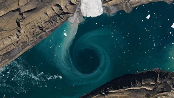
That’s what happened when an image released by NASA showed a peculiar circular structure in the icy waters of Fiord Canyon, a narrow marine inlet located on Ellesmere Island, one of the northernmost inhabited territories on the planet. The formation, visible even from space, looked like a gigantic hole opened in the middle of the ice.
The photograph quickly attracted the attention of the media and science fans. However, there is nothing supernatural about the explanation. According to NASA Earth Observatory specialists, it is a huge oceanic whirlpool generated by the interaction between marine currents, fragments of floating ice and sediments present in the water.
This is how the enormous whirlpool that appeared in an Arctic fjord is formed
The photograph was obtained by the Landsat 8 satellite, developed jointly by NASA and the United States Geological Survey (USGS), over Fiord Canyon, a narrow sea inlet located on Ellesmere Island, in the far north of Canada.
What looked like a gigantic dark circle from hundreds of kilometers above was, in reality, a large oceanic whirlpool. The current spun fragments of ice, sediment and water, creating a figure perfectly visible from space.
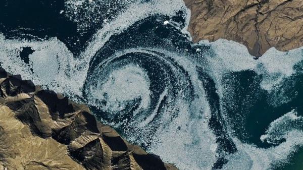
According to NASA Earth Observatory, these types of structures appear when masses of water that circulate at different speeds or in different directions converge. In the Arctic fjords, where seasonal melting, sea currents and a very complex underwater relief coincide, these whirlpools can reach extraordinary dimensions.
For researchers, the image is an excellent example that even seemingly motionless areas of the Arctic maintain intense activity beneath the surface.
Why fjords are key to studying climate change
Fjords are valleys carved by ancient glaciers that were later flooded by the sea. They are characterized by their steep walls, great depths and an intense interaction between fresh water and salt water. Although they are usually associated with Norway, they are also very abundant in Greenland, Canada, Alaska, Chile or New Zealand.
For climate researchers, fjords represent authentic natural laboratories. Some of the most important exchanges between continental glaciers and the ocean occur here.
Research promoted by NASA has shown that relatively warm waters entering some fjords can accelerate melting from the base of glaciers, a key phenomenon for understanding global sea level rise.
Ellesmere Island, one of the coldest and most inhospitable places on the planet
The phenomenon was observed on Ellesmere Island, located in the Canadian Arctic archipelago. With more than 196,000 square kilometers of surface area, it is the tenth largest island in the world and is home to some of the most inhospitable landscapes in the northern hemisphere. For much of the year it remains covered by snow, sea ice and extreme temperatures.
The region is part of the polar ecosystem that is experiencing some of the most rapid changes associated with global warming.
According to the Arctic Monitoring and Assessment Program (AMAP), the Arctic is warming approximately four times faster than the global average, a phenomenon known as Arctic amplification.
This warming is modifying the extent of sea ice, altering entire ecosystems and transforming oceanic processes that until a few decades ago remained relatively stable.
What this phenomenon reveals about the melting of the Arctic
The scientific importance of these images goes far beyond their spectacular nature. The eddies, currents and movements of water observed in the fjords allow researchers to study how heat circulates in the polar regions. And understanding these mechanisms is essential to predict the speed with which certain glaciers could melt in the coming decades.
NASA’s IceBridge mission, along with satellites such as ICESat and GRACE, has been collecting information on the loss of ice mass in Greenland and the Canadian Arctic for years. The data show a significant acceleration of melting since the beginning of the 21st century.
The National Snow and Ice Data Center (NSIDC) has reported that summer Arctic sea ice extent has declined steadily over the past few decades, reaching record lows on several occasions.
Much more than a spectacular image: a tool to monitor the planet
Photographs obtained by satellites such as Landsat make it possible to monitor extremely remote regions where human presence is limited. Thanks to these observations, researchers can follow the evolution of glaciers, sea ice movements, changes in water surface temperature and phenomena such as the one observed in Cañon Fiord.
These images help identify processes that can later be studied in more detail through scientific campaigns in the field.
NASA highlights that many of the big questions about the future of global climate depend on better understanding what is happening in polar regions seemingly far from most people’s daily lives.
In this case, the curious circular structure detected in a remote Canadian fjord ended up being much more than a striking image and became a privileged window to observe the complex interactions between ocean, ice and climate in one of the most sensitive regions on the planet.
If you want to read more articles similar to NASA photographs a huge hole in the middle of an Arctic fjord and its explanation helps to understand climate change, we recommend that you enter our Climate Change category.
- Copernicus Climate Change Service / https://climate.copernicus.eu
- USGS Landsat Program / https://www.usgs.gov/landsat-missions
- Arctic Council / https://arctic-council.org