A violent earthquake hit the Azuero peninsula. The fault, which had remained “silent” for years, had accumulated a tension that was suddenly released: geological causes and the risks for the affected areas.
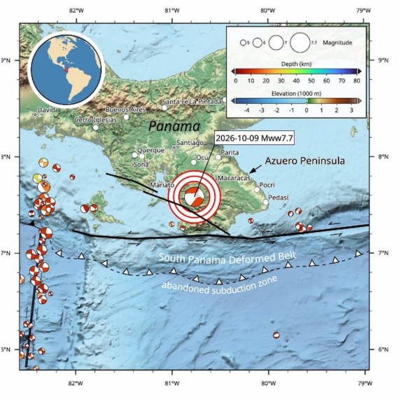
A magnitude 7.7 earthquake struck the area south of the Azuero Peninsula in Panama on October 9, at 12:56 local time. The tremor was felt throughout the country and as far away as Costa Rica, Colombia and Venezuela.
Strong intensity
There is still little information available, but location, depth and magnitude suggest a serious event. Many buildings in the region are not designed to withstand such strong shaking and have never been tested by an earthquake of this magnitude: damage is likely to be widespread.
In some locations, intensities between the VIII and IX Mercalli degrees (which measures destruction) were recorded, from strong to violent, sufficient to damage the most vulnerable buildings. Some damage has already been reported. The witnesses collected by the Euro-Mediterranean Seismological Center (EMSC) speak of very strong tremors, blackouts and objects falling to the ground. USGS estimates are updated over time, so it’s best to check the site for the most recent data.

The most affected areas are those about which less is known
There is still no news from the areas close to the fault, where the shock was strongest. In earthquakes, silence is not a good sign: it usually indicates less developed areas, with more fragile communications. Many media report what was heard in Panama City, about 200 kilometers away, while almost no one talks about Tonosí, a town of about 2,300 inhabitants, or the small rural town of Los Atrales.
The United States has issued a tsunami warning, as per procedure for earthquakes of this magnitude. The first warning, about six minutes after the quake, was based on an estimated magnitude of 8. About fifteen minutes later the value was revised downwards and the alarms were gradually cancelled. Early estimates predicted waves of 1 to 3 meters on some Panamanian coasts, but they did not materialize. The rupture of the fault appears to have occurred almost entirely beneath the mainland and the earthquake is of the strike-slip type, i.e. with horizontal movement: for this reason a destructive tsunami appears unlikely.
A record for Panama
It is probably the strongest earthquake ever to occur on the Panamanian mainland in recorded history. The one in 1882, under the Caribbean Sea, may have been stronger and caused a large tsunami, but the magnitudes of such ancient events are very uncertain.
In 1974, a 7.3 magnitude earthquake hit the border between Colombia and Panama. Paleoseismic excavations have also revealed several large earthquakes (around magnitude 7) along the Pedro Miguel and Limón faults, which cross the Panama Canal. It seems like a typical case of a “dormant” fault: a structure that produces few, if any, earthquakes before triggering a large-magnitude event. It is reminiscent, on a larger scale, of the 2019 Ridgecrest, California, earthquake.
Why was there such a strong earthquake in Panama?
At first glance, the southern coast of Panama appears to be that of a subduction zone, that is, where an oceanic plate slides under a continent, as in much of the American Pacific coast. The seabed that slopes steeply towards the deep sea is typical of these places. But it is only a legacy of the past: that mechanism is turned off today. It can be thought of as an old scar on the skin: the shape remains, but the original wound is no longer active. In its place, under Panama, the main movement is another. The plates do not collide, but slide sideways, past each other, at about 3.5 centimeters per year.
The border is a large fracture that runs from north to south, just west of the 82nd west meridian. West of this line subduction is still active and earthquakes are frequent. To the east, where the Azuero peninsula is located, the area was seismically quiet and nothing like it had ever been recorded. This very calm was deceiving: a fault that remains silent for a long time can accumulate tension and suddenly release it in a large earthquake, as happened on October 9th.
Which fault line has moved? The main suspect
The most likely candidate is the Azuero-Sona fault, which aligns with the zone of strongest shaking modeled by the USGS. We know little about its activity: the few studies have focused mainly on the volcanic rocks it cuts, which are around 20 million years old. A 2010 study by Rockwell and colleagues found geomorphological evidence of fairly recent creep, with left-lateral movement of 5-7 millimeters per year and vertical movement of 9-14 millimeters per year.
It is still too early to say with certainty which fault line has moved. It could be a fault with a northeast/southwest orientation, one that has not yet been mapped, or a network of faults with both orientations: large strike-slip earthquakes often activate multiple nearby faults.
What happens now
A passing earthquake of this magnitude and so superficial should have produced a noticeable rupture on the surface, visible to the inhabitants and probably also from above.
In the next few days, radar satellites will observe the area and allow us to map the extension of the fault and the extent of the slip. Meanwhile, the aftershocks continue. The strongest so far was magnitude 6.6, followed by six others between 5 and 6.