The African continent experiences an extraordinary geological phenomenon that captures scientists’ attention worldwide. Tectonic forces are literally tearing the landmass apart, creating visible fractures that could eventually form a new ocean. This remarkable transformation occurs in East Africa, where three major tectonic plates converge and slowly drift apart.
The Great Rift Valley system reveals continental fracturing
Stretching over 6,000 kilometers from north to south, the Great Rift Valley represents one of Earth’s most spectacular geological features. This massive depression showcases the ongoing process of continental separation, with deep valleys bordered by volcanic peaks including Mount Kilimanjaro, Africa’s highest point. The landscape tells a story spanning 25 million years of geological evolution.
The rift system demonstrates how tectonic movements shape continents over geological time. Ancient volcanic activity created the dramatic topography visible today, while ongoing plate movements continue modifying the terrain. Scientists study this region to understand how continents split and new ocean basins form, making it a natural laboratory for geological research.
The Afar region serves as a crucial observation point where the rift meets the Red Sea. Here, researchers document the transition from continental rifting to oceanic spreading, providing insights into how new ocean basins develop. This area experiences intense geological activity, with frequent seismic events and volcanic eruptions marking the active separation process.
| Region | Annual Separation Rate | Key Features |
|---|---|---|
| Afar Triangle | 15-20 mm/year | Active volcanism, salt deposits |
| Ethiopian Highlands | 5-10 mm/year | Plateau uplift, rift shoulders |
| Kenya Rift | 2-5 mm/year | Lake systems, volcanic centers |
Somali plate movement accelerates continental separation
The Horn of Africa sits at the intersection of three tectonic plates : the Somalian, African, and Arabian plates. This strategic position creates the perfect conditions for continental rifting, as these massive rock formations gradually move apart. The Somalian plate drifts eastward at several millimeters annually, stretching the continental crust beyond its breaking point.
Geologists monitor this slow but relentless separation using sophisticated satellite technology and ground-based measurements. The process resembles pulling apart a piece of taffy, with the continental crust gradually thinning until it eventually breaks completely. When this happens, seawater will flood the depression, creating a new ocean basin.
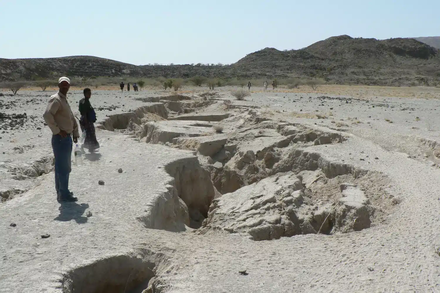
The 2005 seismic events in Ethiopia dramatically altered scientific understanding of rifting timescales. A 60-kilometer fissure opened in just minutes, with the ground separating by two meters almost instantaneously. This event, which should have taken centuries under normal circumstances, suggests that continental breakup might occur faster than previously estimated. Similar dramatic geological events have been observed in other parts of the world, including earthquake activity in volcanic regions that demonstrate the Earth’s dynamic nature.
Future oceanic formation transforms East African geography
Scientists predict that the emerging new ocean basin will extend from the Afar region to Kenya, potentially reaching the Tanzanian border. This massive body of water will transform the Horn of Africa into a large island, fundamentally altering the continent’s geography and affecting regional climate patterns.
The formation process follows established patterns observed in other ocean basins worldwide. As continental rifting progresses, the crust continues thinning until volcanic activity creates new oceanic crust. Eventually, seawater floods the depression, establishing a permanent marine environment that will continue expanding over geological time.
Understanding these processes helps scientists study similar phenomena elsewhere on Earth and beyond. Just as researchers make astounding discoveries beneath Antarctic ice, geological investigations reveal Earth’s hidden mechanisms. The African rift system provides valuable data for planetary science research, contributing to our understanding of how rocky planets evolve.
Scientific implications for global geological understanding
Professor Gilles Chazot from the University of Western Brittany explains that “oceans on Earth are born from the fracturing of a continent that separates in two.” This fundamental process has shaped our planet’s surface throughout geological history, creating the Atlantic and Indian Oceans through similar continental breakup events.
The African rift system offers unique insights into early stages of ocean formation. Researchers can observe the complete sequence from initial continental stretching to eventual oceanic spreading, providing a comprehensive view of geological processes. This research contributes to broader scientific understanding, much like how new discoveries rewrite our understanding of planetary systems.
Key factors influencing rifting include :
- Mantle plume activity driving upward heat flow
- Regional stress patterns from plate boundary forces
- Crustal composition affecting strength and behavior
- Pre-existing weaknesses focusing deformation
Modern monitoring techniques enable scientists to track real-time geological changes with unprecedented precision. Satellite measurements, seismic networks, and GPS stations provide continuous data about crustal movements, helping researchers understand the complex interactions driving continental separation. This ongoing transformation fascinates the global scientific community and continues revealing new insights about our planet’s dynamic nature.
Would have appreciated a map with arrows showing the splitting direction clearly
I agree- a map with arrows and a future map showing what might result would help the signicance of the article, for me at least
Yeah! Me too!
Right!
Also, if it’s just the Horn region breaking off I feel it would just be creating a Bay Area around an island not an “Ocean”, so title was a little misleading.
But still interesting and informative nothing more or less , I guess.
This is such an interesting article! The geological changes happening in Africa are mind-blowing. I had no idea a new ocean could form like this. Can’t wait to see how this develops!
A map would have been useful.
Evolution is happening all around us.
Whaoo!! Its quite interesting to know this. Thanks a lot for your research. I will be very happy to near more.
I know, right?????
I know right???
A map would save us from lots of words
Yes the Great East African Rift system is the current continetal break down, that shows as live evidences how continents and ocean bodies are formed. These type of phenonenas never happened after the creation of modern human beings (Homo Sapiens) in the planet earth.
Well Africa splitting it isn’t the 1st time if u look at a map u can tell it split from south America a long time ago and more recently Madagascar also split from mainland Africa.
Very educative piece. Nature keeps on adjusting itself as charges in the underground formation keep on unfolding.
Very educative piece. Nature keeps on adjusting itself as changes in the underground formation keep on unfolding.
Apparently, the world is changing every single day
It will take millions of years for it to form though. We will be long dead
The geologic time frames regarding this tectonic movement, are not given in this article. It would be fun to have an idea of the length of time before, salt water would enter that basin. Maybe 30 million years? 20? The glaciers melted 10, 000 years ago, and we can still see the geologic scars from that process, Here in Wa. State. So I would presume that for an ocean to form, or even salt water to enter that basin being discussed, would take millions of years.
I’m guessing it rips up Kenya and Ethiopia into halves? By when does data predict could this cleft widen enough to represent a physical barrier to transport across? Is it moving North towards Asia as well? Any thoughts or studies on the socio-economic repercussions for the 3 affected countries? What are the major local communities and species that stand to be segregated?
Can we see a map like or illustration of it?
A very interesting article. What you forgot to mention is the time frame this process will take. It will take shape over millions of years. Man may not even be around by then. Usually when these kind of riffs happen, parts of the mantle are exposed, causing massive volcanic activity. This would put extreme amounts CO2 in the atmosphere, possibly setting off a ice age. I don’t think we will be around to witness it 😉