Mapped under the reliefs of the Eifel (Western Germany) one of the most complex and least known volcanic systems in Europe.
Beneath the Eifel mountains, in western Germany, lies one of the most complex and least known volcanic systems in Europe. Several hundred volcanoes, now apparently dormant, dot the subsoil of this region: they are part of the so-called distributed volcanic fieldsa form of intraplate volcanism – that is, within an earth plate, where there are no collisions between plates (still little studied but potentially insidious).
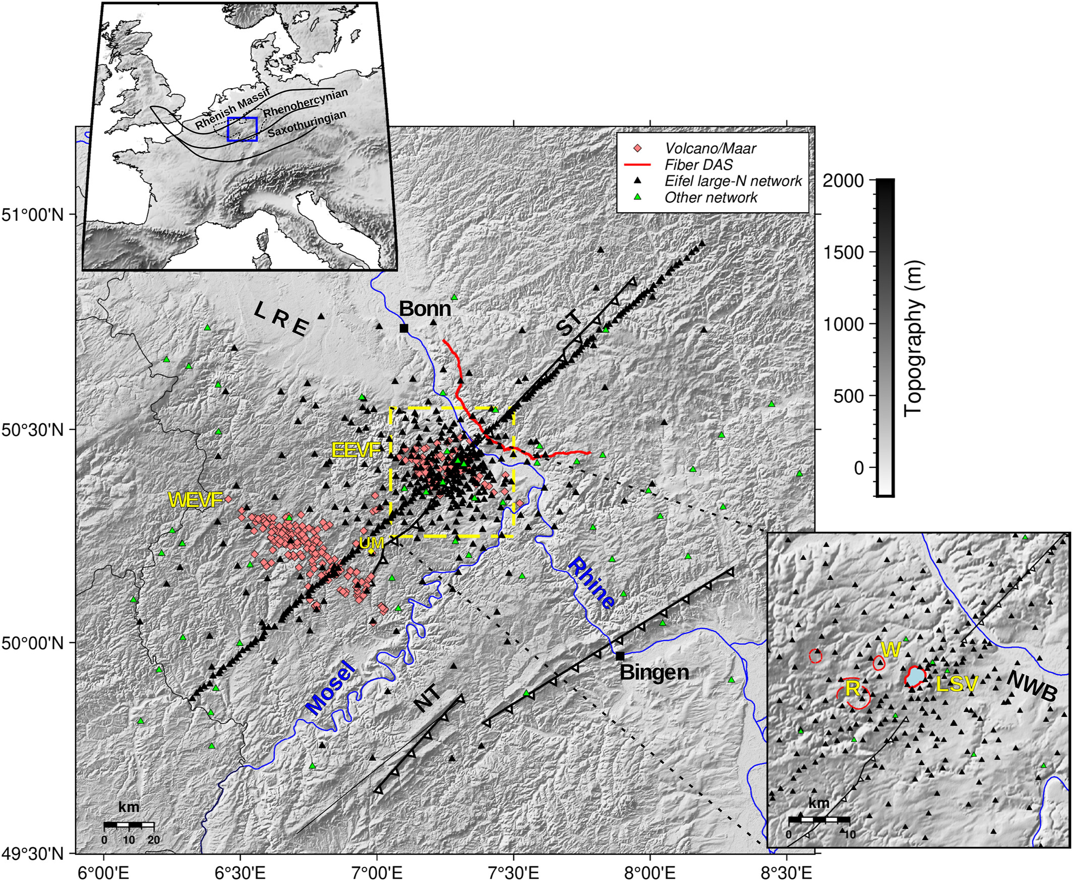
the study. To better understand their origin, evolution and possible future risks, between September 2022 and August 2023 an international team led by the Helmholtz Center for Geosciences (GFZ) carried out the largest seismological experiment ever conducted on volcanoes in Germany. The investigation, which involved universities and seismic services in Germany and Luxembourg, made it possible to obtain very high resolution images of the deep structures beneath the Eifel volcanoes for the first time.
The results of the Eifel Large-N experiment have been published in journals Seismic, Journal of Geophysical Research: Solid Earth And Geophysical Journal International
An innovative system. The experiment, known as Eifel Large-Nemployed over 500 temporary seismic stations, placed at distances of less than two kilometers, and innovative technology based on a 64 kilometer long fiber optic cable. This method, called Distributed Acoustic Sensing (DAS), exploits the extreme sensitivity of the optical fiber to the slightest deformations, allowing you to “listen” to subsurface vibrations that would otherwise escape traditional sensors.
Thanks to this unprecedented network, researchers have managed to produce the most detailed map ever made of the magmatic system responsible for the great eruption of Lake Laach, which occurred around 13 thousand years ago. It was a highly explosive event, lasting a few days, which covered vast areas of central Europe with ash and pyroclastic flows, leaving clearly visible deposits near Mendig, south of the lake.
The news. Until now, the dimensions and depth of the Laach magma chamber could only be deduced indirectly from the study of the tephra deposits – i.e. fragments of volcanic material (ash, lapilli, bombs) expelled during an eruption – emerging on the surface.
The new tomographic images instead tell a story that was previously unknown: the magma reservoir is located at a depth of up to ten kilometers, lower than previously assumed, and has an inclined, not vertical, orientation. The anomaly in fact extends diagonally towards the Neuwied basin, an area that concentrates much of the current seismicity of the Vulkaneifel.
microearthquakes. Another surprising result concerns the high number of microearthquakes recorded: in just one year, over a thousand were located.
Most are concentrated along a narrow vertical band between Ochtendung and Lake Laach, but other seismic clusters emerge at the edges of areas with anomalous seismic velocity compared to the rest of the area.
An unexpected behavior, which could indicate locally warmer areas or fluid rising processes. “The strong reflections of seismic waves at the boundaries between the upper and lower crust beneath the Neuwied basin are also unusual,” explains Torsten Dahm, professor and scientific leader of the experiment. «The intensity of these reflections suggests the accumulation of fluids. We still don’t know whether it is real magma or fluids of magmatic origin: it will be necessary to investigate further with more advanced analysis methods.”
Scattered all over the world. “Distributed volcanic fields”, such as that of the Eifel, extend over areas between 1,000 and 10,000 square kilometers and are characterized by numerous eruptive centres, often active only once in their history.
Similar examples are found in the French Massif Central, Arizona (San Francisco volcanic field), China, and the Auckland volcanic field, New Zealand. Precisely this apparent “unpredictability”, with eruptions that can occur in always different points, makes the detailed mapping of deep magmatic systems fundamental.