A major breakthrough in ocean floor mapping has occurred with the latest data from NASA’s Surface Water and Ocean Topography (SWOT) satellite revealing approximately 100,000 seamounts across the globe. This detailed cartography represents a significant advancement in our understanding of underwater topography, nearly doubling previous estimates of 44,000 known seamounts.
Revolutionary mapping of the ocean floor
Scientists have been working for decades to develop comprehensive maps of the ocean floor, which covers more than 70% of our planet. The recent publication of one of the most detailed seafloor maps ever created marks a watershed moment in marine exploration. Using data from NASA’s SWOT satellite, researchers have unveiled underwater landscapes previously hidden from human knowledge.
David Sandwell, a geophysicist at the Scripps Institution of Oceanography who has been mapping the seafloor using satellite data since the 1990s, emphasizes the significance of this advancement: The SWOT satellite represents a breakthrough in our capacity to map the ocean floor. His team’s findings, published in Science in December 2024, showcase the remarkable precision of this new mapping technology.
The SWOT satellite, a collaborative project between NASA and the French space agency CNES, covers approximately 90% of the planet every 21 days. This frequent revisiting allows the satellite to detect subtle centimeter-scale differences in sea surface height caused by underlying seafloor features. The technology works because geological formations like seamounts have greater mass than their surroundings, creating slightly stronger gravitational pulls that form measurable bumps on the sea surface.
Previous ocean observation satellites could only detect massive seafloor formations, such as seamounts taller than one kilometer. The advanced technological capabilities of modern space missions now allow detection of features less than half that height, dramatically expanding our underwater vision.
Types of underwater geological formations revealed
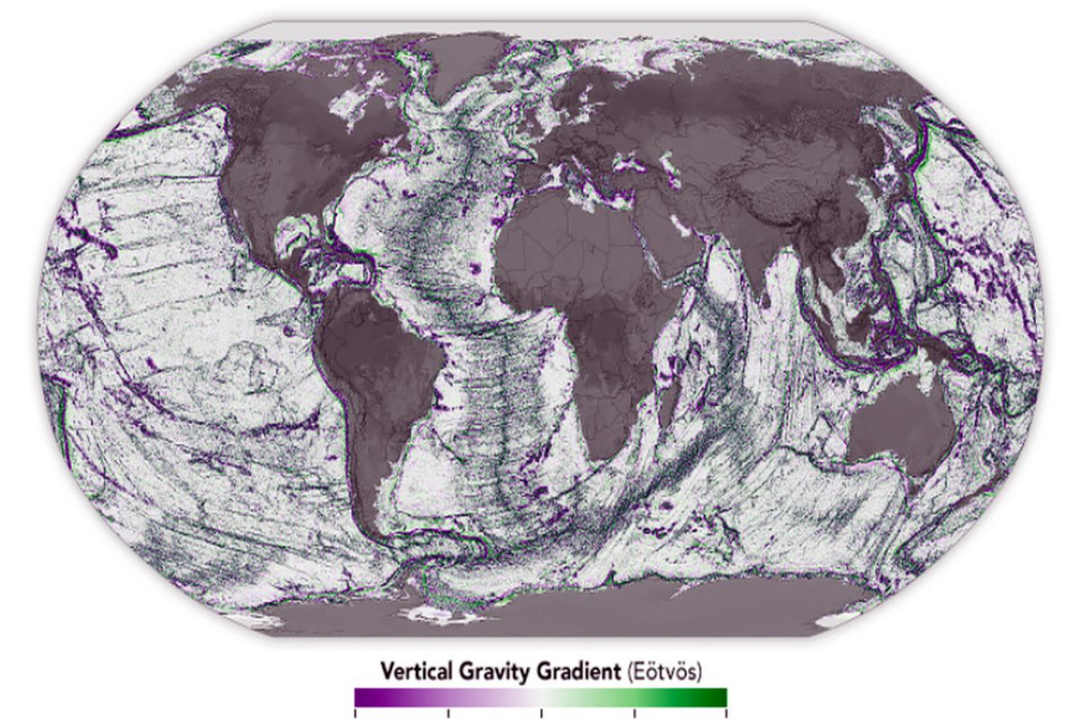
The newly mapped seafloor reveals several distinct geological formations that shape our understanding of Earth’s underwater landscapes:
- Seamounts – underwater mountains rising at least 1,000 meters from the seafloor
- Abyssal hills – smaller elevations forming in parallel bands
- Continental margins – areas where continental crust meets oceanic crust
- Fracture zones – linear features where tectonic plates have shifted
- Deep ocean trenches – the deepest parts of the ocean floor
Yao Yu, an oceanographer at Scripps Institution of Oceanography and lead author of the study, notes: Abyssal hills constitute the most abundant landform on Earth, covering approximately 70% of the ocean floor. These hills form in parallel bands, similar to washboard ridges, where tectonic plates move away from each other. Their orientation and extent reveal historical tectonic plate movements.
The detailed mapping shows these formations as distinct color patterns – areas of reduced gravity (depressions) appear in purple, while areas of increased gravity (elevated structures) show in green. This visualization technique helps scientists interpret complex underwater landscapes across vast oceanic regions.
While direct sonar measurements from ships provide incredibly detailed seafloor measurements, only about 25% of the ocean floor has been studied this way. Satellite data now fills crucial gaps in our understanding of these hidden landscapes that influence our planet’s geological processes in profound ways.
Ecological importance of underwater mountains
Seamounts serve as underwater oases, concentrating nutrients on their slopes and attracting diverse marine organisms. They penetrate into water currents, influencing deep-sea circulation patterns and creating unique habitats in otherwise barren areas of the ocean floor. The discovery of tens of thousands of previously unmapped seamounts suggests there are many more of these biodiversity hotspots than previously realized.
Recent discoveries of living microbes in ancient rock formations highlight how these underwater geological features may harbor unique life forms adapted to extreme conditions. The ecological significance of these underwater mountains extends beyond their physical presence, potentially supporting specialized ecosystems that remain largely unexplored.
| Seafloor Feature | Previously Known | Newly Estimated | Ecological Role |
|---|---|---|---|
| Seamounts | 44,000 | 100,000 | Biodiversity hotspots, nutrient concentration |
| Abyssal Hills | Partially mapped | Cover ~70% of ocean floor | Influence deep currents and tides |
| Continental Margins | Well-known locations | More detailed boundaries | Transition zones with unique habitats |
Applications beyond scientific discovery
Detailed seafloor maps serve crucial practical purposes beyond scientific understanding. These maps prove essential for various maritime activities, including safe navigation and the strategic placement of underwater communication cables that form the backbone of our global internet infrastructure.
Understanding seafloor topography also improves our knowledge of deep-sea currents and tides that affect marine life and influence weather patterns. The abyssal hills and other formations interact with ocean currents in ways scientists are still working to fully comprehend. This understanding becomes increasingly important as climate change impacts various Earth systems in complex ways.
The enhanced vision provided by SWOT delivers valuable insights into Earth’s geological history. By examining the patterns of seafloor formations, scientists can reconstruct past tectonic movements and better understand the forces that have shaped our planet over billions of years. This geological perspective helps contextualize current planetary changes within Earth’s long history.
The gravitational mapping technique represents a remarkable fusion of space technology and marine exploration, demonstrating how observations from orbit can reveal landscapes hidden beneath miles of ocean water. Similar remote sensing approaches might someday help scientists explore other worlds with subsurface oceans, such as Jupiter’s moon Europa.
The mapping techniques developed for this project could potentially be applied to astronomical observations of distant planetary systems, helping scientists detect surface features on exoplanets. Just as SWOT measures tiny variations in Earth’s ocean surface to reveal what lies beneath, future telescopes might analyze the light from distant worlds to map their features.
This landmark mapping project demonstrates the life-giving importance of scientific exploration, revealing a hidden world beneath the waves that influences everything from marine biodiversity to global climate patterns. As technology continues to advance, our understanding of Earth’s final frontier – the deep ocean – will only grow more sophisticated and complete.