
The Sahel is a geographical region of Africa that extends in the form of a strip from the Atlantic Ocean to the Red Sea (west – east), located between the Sahara Desert to the north and the savannahs to the south. Therefore, this region with a semi-arid climate crosses countries such as Senegal, Mauritania, Niger and Eritrea, among many others.
In this Evidence Network article we are going to give you a general analysis of what the Sahel is, addressing its countries, climate, flora, fauna and the conflict that affects the region.
What is the Sahel?
The Sahel is a geographical and climatic region of Africa that extends from west to east, from the Atlantic Ocean to the Red Sea. It is located just south of the Sahara Desert and north of the tropical savannas, forming a kind of transition strip between these two areas. Therefore, it covers the areas of various countries.
What is the difference between the Sahel and the Sahara?
- The Sahara is the largest hot desert in the world, characterized by its extremely arid climate and sparse vegetation. Learn about the largest deserts in the world here.
- The Sahel, on the other hand, is a semi-arid strip located south of the Sahara, which acts as a transition zone towards the African savannahs. In the Sahel there is more seasonal rainfall and sparse vegetation, making it more suitable for agriculture and grazing.
What are the countries of the Sahel?
The countries that are part of the Sahel do not have strict limits, since it is a region that is more ecological and climatic than political. However, the following countries are commonly considered part of the Sahel:
- Senegal
- Mauritania
- Mali
- Burkina Faso
- Niger
- Chad
- Sudan
- Eritrea
Some experts also include parts of northern Nigeria, Cameroon, Ethiopia and Gambia as they share similar characteristics in terms of climate and social and environmental challenges.
These countries face common problems such as water scarcity, pressure on natural resources, accelerated population growth and political instability. Many of them are also exposed to armed conflicts and forced displacement, which worsens the humanitarian situation in the region.
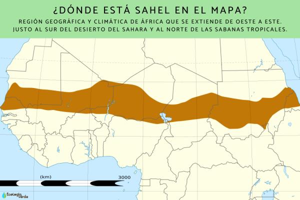
To better understand the extent and location of this area, just look at a map of the Sahel. In it you can see how this strip crosses the African continent from west to east, just south of the Sahara Desert.
Where is Sahel on the map?
What are the geographical characteristics of the Sahel?
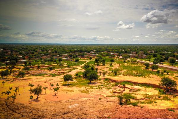
The Sahel presents a series of unique geographical characteristics that make it a particularly fragile region and vulnerable to environmental changes. It extends for about 5,400 km from the Atlantic Ocean to the Red Sea, with a width that varies between 400 and 600 km. This strip crosses Africa horizontally, functioning as a transition zone between the Sahara Desert, to the north, and the greener savannahs of sub-Saharan Africa, to the south.
Its landscape is dominated by vast semi-arid plains, with little vegetation, predominantly low shrubs, drought-resistant grasses and some scattered trees such as acacia. One of the main geographical and environmental problems facing this region is desertification. Desertification in the Sahel, and in any other region, occurs when soils lose their fertility and capacity to retain water, which favors the expansion of the Sahara Desert towards the south. Soil degradation is a direct consequence of the overexploitation of natural resources, such as overgrazing, deforestation and intensive cultivation on fragile lands. Here you can learn about Desertification: what it is, causes and consequences.
Over time, these practices, added to climate change, have reduced vegetation cover and eroded soils, causing a drop in agricultural production and greater food insecurity. Millions of people directly depend on these lands to live, so desertification and soil degradation are not only environmental problems, but also social and economic ones.

What is the climate of the Sahel like?
The climate of the Sahel is semi-arid, meaning that it is hot and dry most of the year, with a brief rainy season. This rainy season usually lasts between one and three months, depending on the area, and is mainly concentrated between June and September. However, rainfall is irregular, both in quantity and distribution, making it difficult to predict and unreliable for agriculture.
In addition to drought, another common climatic phenomenon in this region is sand storms in the Sahel. These storms, also known as “haboobs”, occur when strong winds raise dust and sand from the dry ground, creating dense clouds that can reduce visibility to a few meters and seriously affect people’s respiratory health. These storms can last from a few hours to several days and are becoming more frequent due to soil degradation and the lack of vegetation to hold them in place. In this other post you can read more about Sandstorms: what they are, how they form and consequences.
What is the flora of the Sahel like?
Drought resistant vegetation
The flora of the Sahel is mainly made up of plants resistant to drought and lack of nutrients. Among the most common species are thorny shrubs, seasonal grasses and some scattered trees. These plants usually have very deep roots to search for underground water or small, hard leaves that reduce moisture loss through evaporation.
Trees
Some typical trees of the Sahel are:
- Acacia: very common in the region, it is a thorny tree that can survive with very little water.
- The baobab: known for its thick trunk that stores water, it is a symbol of resistance in arid climates. Here you will learn more about Baobabs: what they are and characteristics.
- The shea tree: in addition to adapting well to the conditions of the Sahel, it produces a nut from which shea butter is extracted, widely used both locally and in the international cosmetic industry.
Grasses and shrubs
During the short rainy season, the Sahel is temporarily covered with herbs, grasses and low bushes, which serve as food for livestock.

What is the fauna of the Sahel like?
Mammals adapted to heat
Among the most common mammals in the Sahel are species capable of withstanding high temperatures and long periods without water. Some examples are:
- The dromedary: the dromedary, also known as the Arabian camel, is a key animal for nomadic populations, as it adapts perfectly to dry climates, can travel long distances without water and transport heavy loads.
- Gazelles: They are light and fast antelopes that live in open areas.
- The jackal: an opportunistic carnivore that adapts to different conditions and feeds on both small prey and carrion.
Migratory and resident birds
The Sahel is also an important area for many migratory birds, especially during the European winter. These birds use the Sahel as a resting and feeding area. Among them stand out:
- The white stork
- The black kite
- The European bee-eater
In addition, local birds such as the ostrich or the francolin have adapted to living in dry, open terrain, feeding on seeds, insects and small reptiles.
Reptiles
Among the animals of the Sahel, species such as:
- The desert monitor
- Various species of snakes, some poisonous.
insects
As for insects, they are abundant during the rainy season. They stand out:
- Beetles and termites, which play an essential ecological role by decomposing organic matter. Learn here the Differences between ants and termites.
- Desert locusts, which can form destructive swarms and destroy crops, worsening food insecurity in the region.

What is the Sahel conflict?
The conflict in the Sahel region is one of the most complex and worrying in the world today. Many of the Sahel countries are among the poorest countries in the world. The lack of employment, education and basic services fuels frustration and leaves millions of young people without a clear future.
Different ethnic and religious groups coexist in this area. Historical tensions, coupled with state abandonment, have led to clashes between communities, especially between nomadic herders and farmers competing for scarce natural resources.
For more than a decade, extremist groups such as Al Qaeda in the Islamic Maghreb (AQIM), the Islamic State of the Greater Sahara (EIGS) and Boko Haram have taken advantage of the power vacuum in remote areas of the Sahel to expand. These groups spread fear, attack civilians, recruit young people and destabilize governments.
On the other hand, desertification, soil degradation, and water scarcity have aggravated conflicts over land use. The reduction of vegetation in the Sahel and the loss of grazing areas have intensified disputes between ranchers and farmers, and have forced many people to migrate in search of better conditions.

Other frequently asked questions about the Sahel
Why is the Sahel a vulnerable region?
Because it combines an extreme climate with scarce and irregular rainfall, fragile soils and high dependence on agriculture and grazing, which makes it very sensitive to droughts and food crises.
What environmental problems does the Sahel face?
Mainly, it faces problems such as: desertification, soil degradation, loss of biodiversity, overgrazing and prolonged droughts aggravated by climate change.
What are the causes of conflicts in the Sahel?
The main causes of conflicts in the Sahel are: dispute over scarce resources such as water and fertile lands, food insecurity, ethnic tensions and the presence of armed groups.
What is grown in the Sahel?
The crops are mainly millet, sorghum, corn, peanuts and legumes, along with some livestock in agropastoral systems.
What is the Great Green Wall in the Sahel?
A pan-African project that seeks to restore degraded lands by planting a strip of vegetation to curb desertification and improve livelihoods.
If you want to read more articles similar to Sahel: what it is, countries, climate, flora, fauna and conflict, we recommend that you enter our Ecosystems category.
- Diplomatic Raia. (2025, April 28). What is the Sahel? Exploring its geography, countries and the complex political situation. Diplomatic Raia. Available at: https://raiadiplomatica.info/2025/04/28/que-es-el-sahel-explorando-su-geografia-paises-y-la-compleja-situacion-politica/
- Africa House. (sf). Climate migrations and the Sahel. Africa House. Available at: https://www.casafrica.es/sites/default/files/contents/document/0._libro_migraciones_climaticas_y_sahel_para_maqueta.pdf
- López, A. (2024, April 8). Exploring the Sahel: conflict, location and causes. Help in Action. Available at: https://ayudaenaccion.org/blog/ayuda-humanitaria/sahel-conflicto/
- EcoAvant. (2018, April 4). The fauna of the Sahara and the Sahel in danger of extinction. EcoAvant. Available at: https://www.ecoavant.com/actualidad/en-peligro-de-extincion-la-fauna-del-sahara-y-el-sahel_3763_102.html
- More Blue Planet. (2021, May 7). Forests in the Sahara and the Sahel? More Blue Planet. Available at: https://www.masazulplaneta.com.ar/2021/05/07/bosques-en-el-sahara-y-el-sahel/
- GeoHistoricos (blog). (2011, December 2). The Sahel. GeoHistorics. Available at: https://geohistoricos.blogspot.com/2011/12/el-sahel.html