Atmospheric conditions can lead to intense phenomena that directly impact on everyday life and the environment. One of them is the turbonada, a sudden manifestation of very strong winds, generally accompanied by intense rain and associated with clouds of great vertical development.
In this ecology article, we will tell you in detail what a turbonada is, how it is formed and its differences with a storm and a tornado.
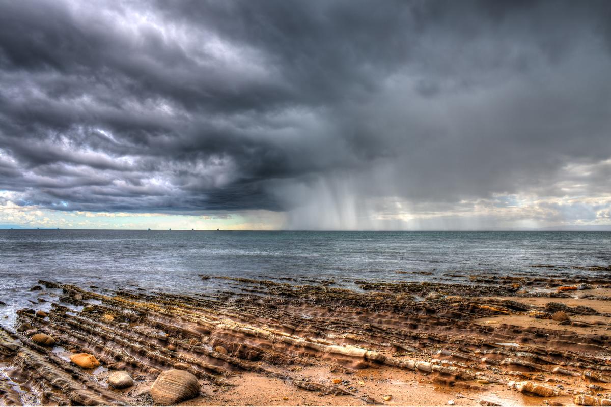
What is a turbonada?
A turbonada is a meteorological phenomenon characterized by the sudden appearance of very strong winds, accompanied by intense rains, thunderstorms and even hail. Its main feature is the violence and speed with which it manifests, since it can be unleashed in a matter of minutes, surprising those who are outdoors or in maritime activities.
Unlike a common strong wind, the turbonada usually has a more severe impact, since it can tear down trees, affect ceilings, interrupt electrical services and complicate navigation. In addition, although its duration is usually brief, the damage it causes can be considerable.
In coastal regions, this type of event is especially feared by fishermen and navigators, as it can appear unexpectedly in the midst of what seemed like a quiet day. Therefore, the turbonada is considered a natural warning of the force and unpredictability of the climate.
In this link you can inform yourself about when strong wind is considered.

How is a turbonada formed?
The turbonada appears suddenly, but has an order of appearance of the different phenomena that compose it. Let’s see step by step how a turbonada forms:
- Warm and very humid air on the surface: it accumulates near the ground, especially after a embarrassing day. That energy “fuel” is the basis of the process.
- Atmospheric instability: hot air tends to rise because it is less dense than the coldest air from above. When the atmosphere is unstable, that ascent accelerates.
- Wind shear: speed changes and/or direction with the height organize the storm and facilitate intense currents inside the cloud. Learn more about the wind shear: what it is, how it occurs and effects here.
- Cumulonimbus Development: Ascending currents form a cloud of great vertical development with powerful convective towers.
- Intense ascending current: Inside the cumulonimbus, the air rises rapidly, condenses water vapor and releases heat, which further reinforces the storm.
- Cooling and precipitation load: rain drops, hail and evaporation from that precipitation cool the air in the cloud. This denser air begins to descend.
- Descending current: the “jet” of cold and heavy air falls strongly from the cumulonimbus to the surface, dragging rain and sometimes hail.
- Racing front: When touching earth, the descending air is “scattering” horizontally, forming a cold air front that advances like a wave and pushes the warm air it finds in its path.
- Sudden and generalized gusts: that advance of the streak front causes very strong and sudden winds on the surface, often in a wide strip and in a short time: that is the turbonada.
- Displacement and dissipation: The turbonada moves with the storm or the storm line; It loses strength when the supply of warm and humid air decreases or the structure of the cumulonimbus weakens.
What characteristics does a turbonada have?
Turbonadas have a series of features that distinguish them from other meteorological phenomena. Among the most important are:
- Wind intensity: it is its most striking characteristic. Winds can reach very high speeds in a few seconds. They feel like violent bursts, capable of moving loose objects, knocking down trees or causing damage to light structures.
- Duration: Although the impact can be very strong, the turbonada does not usually extend too much. It usually lasts between 10 and 30 minutes, although the moment of greatest intensity is concentrated in just a few moments.
- Immediate effects: They suddenly manifest cuts of energy, fall of branches or posts, accidents in traffic, complications for boats and abrupt reduction of visibility due to intense rain or dust raised by the wind.
- Sudden appearance: unlike other more predictable phenomena, a turbonada can surprise without much notice, which makes it especially dangerous.
- Association with storms: it almost always originates in the framework of strong storms and is linked to clouds of great vertical development such as cumulonimbus.
Together, the turbonada is characterized by being brief, intense and with considerable destructive power in its immediate environment.
What are the possible consequences of a turbonada?
We have already seen that the turbonada is characterized by its intensity in the winds and, although it usually lasts a short time, it can have various consequences. Let’s see which are the most important:
- Material damage to homes and light buildings, such as torn roofs, broken windows or weakened structures.
- Fall of trees and branches, at risk of obstructing streets, damaging vehicles or interrupting traffic.
- Cuts in the electricity and communications supply, due to the fall of posts or cables.
- Road accidents, caused by visibility reduction, objects dragged by wind or slippery soils.
- Difficulties in navigation and fishing, especially in coastal areas, since it can turn small boats.
- Affectation to agriculture, with crops damaged by hail, wind or excess water in a very short time.
- Risk for the integrity of people, both direct impacts of projected objects and sudden landslides or floods.

Where are turbonated more frequent?
Turbonadas are more frequent in coastal areas and in areas close to large mass of water, such as the Mediterranean and Atlantic Sea, where temperature and humidity contrasts favor their formation. They also usually occur in tropical and subtropical regions, especially in summer, when intense heat generates very active storm clouds.
In Spain, for example, they are common on the Mediterranean coast and in the Ebro Valley. In Latin America, for example, they are frequent in places such as the Río de la Plata basin, in the Amazon region and on the Pacific coast in Central America.
How to protect yourself during a turbonada?
During a turbonada, the most important thing is to protect yourself from intense wind and the possible fall of objects. Some recommendations are:
- Take refuge in a safe place, preferably within a solid construction and away from windows and doors.
- Avoid being on the street or in open areas, since the wind can drag branches, posters or even vehicles.
- Do not protect yourself under trees or light structures, because there is a risk of falling.
- If it drives, stop in a safe place until the phenomenon passes.
- Stay informed through weather alerts to act quickly.
How is a turbonada from a storm and a tornado?
Although they usually confuse, a turbonada, a storm and a tornado are not the same. Each has their own characteristics that distinguish them:
- Turbonada: It is a very strong and sudden wind episode, generated by the cold air descending of a cumulonimbus. It is brief, violent and can cause material damage, but does not have organized rotation like a tornado.
- Storm: It is a broader atmospheric phenomenon, which includes intense rain, thunder, lightning, hail and wind. A storm can give rise to a turbonada, but not all storms generate this type of violent bursts. Here you can learn more about storms: what they are, how they form, types and their difference with rain.
- Tornado: It is a column of air in rotation, extremely violent and with contact between the cloud and the earth’s surface. Unlike the turbonada, the tornado is much more destructive and localized, with winds that can exceed 300 km/h. In this other post we tell you more about the tornado: what is, how it is formed, types and consequences.
In a nutshell, the storm is the general phenomenon, the turbonada is a burst of intense winds within that context, and the tornado is a more extreme and dangerous manifestation, marked by the air rotation.
If you want to read more articles similar to turbonada: what it is, how it is formed and differences with a storm and a tornado, we recommend that you enter our category of meteorological phenomena.
- Scribd. Turbonada. Available at: https://es.scribd.com/document/524227685/turbonada
- EL FINANCIERO DRAFTING. (June 28, 2024). The financial. What is a turbonada, a phenomenon that causes extreme rains in Yucatan? Available at: https://www.elfinanciero.com.mx/nacional/2024/06/28/lluvias-en-mexico-2024-turbonada-que-es-signified-y-como-affecta-con-vientos-e-inundaciones-en-yucatan/
- Dictionary Bible. Turbonada: What is, concept and definition. Available at: https://www.bibliode.com/diccionario-biblico/turbonada
- United Nations Office For Disaster Risk Reduction (UNDRRR). Squall. Available at: https://www.undr.org/understnding-disaster-risk/terminology/HIPS/MH0304
- American Meteorological Society (AMS), 2012. Glossary of Meteorology: Squall. American Meteorological Society (AMS). Available at: https://glossary.ametsoc.org/wiki/squall